Cape Charles Rotary Computers for Boys and Girls Club

At the check presentation ceremony: Bill Payne, Eastern Shore Boys and Girls Club Chairman and Kathy Custis, Executive Director, with John Burdiss, Cape Charles Rotary past president, and Allan Burns, current president.
February marks the beginning of a special new partnership between the Rotary Club of Cape Charles and the Eastern Shore Boys and Girls Club. The Rotary Club will bring much-needed technology and career mentorship to local youth in order to provide the teens a jumpstart on successful careers. The first step is a grant of $4,000 to the local Boys and Girls Club.In addition to the grant, Cape Charles Rotary will conduct a Career Day for the Eastern Shore Boys and Girls Club at Occohannock Elementary School February 21 from 9:30 a.m. until 1:30 p.m. According to Kathy Custis, Executive Director of the Eastern Shore Boys and Girls Club, “This generous grant will be used to purchase computers in support of the upcoming Career Day and various other Boys and Girls Club programs. We are so grateful that this will be an ongoing relationship with the Cape Charles Rotary Club.” [Read more…]
Fiery Retort to Official’s ‘Information Paper’ on Rezoning
CAPE CHARLES WAVE
February 9, 2015
An “Information Paper” by Northampton County Economic Development Director Charles McSwain is being fiercely challenged by the anti-rezoning group “Citizens for Open Government,” led by Exmore businessman Ken Dufty.
McSwain challenges “statements made in flyers over the past year” with a “point-by-point” response. Dufty, rising to the challenge, is refuting McSwain’s claims. The Wave reports the battle below, but readers looking for something shorter should CLICK for Wayne Creed’s report. A Letter to the Editor from Ken Dufty was received after both these reports were compiled. CLICK to read the letter.
McSWAIN CHARGES: Flyer says “Rezoning of nearly 3,000 acres of agricultural lands to residential and commercial use.” In fact, 3960 currently agriculturally zoned acres were redistricted to other uses more consistent with their actual current use or in the case of commercial property, their highest and best use consistent with adjacent existing uses and planned infrastructure. In addition, 4845 acres were rezoned from other uses to Agriculture. The net change in the proposed draft is an increase in agricultural district zoning by 885 acres of land. The flier statement is misleading. The County will have more agriculture district land.
DUFTY RESPONDS: While attempting to persuade that this statement is false or misleading, McSwain admits that the flyer underestimated the rezoning of agricultural lands that were redistricted to other uses. The McSwain paper states that in fact, 3960 currently agriculturally zoned acres were redistricted to other uses.However, the paper also states that other lands were rezoned to agricultural lands, making the net change 885 acres more agricultural land than previously districted. This criticism of the flyer is misplaced at best, and in reality misses our entire point regarding this rezoning. First, the majority of landowners who own ag land under the current zoning ordinance and who are proposed to be rezoned into residential or other uses, never petitioned the county for that rezoning classification. The redistricting of ag lands to a higher or best use without the request of the individual landowners is impermissible, and is akin to a taking, and the redistricting will potentially result in tax increases on the property owners who have had their lands reclassified without their consent. Also, our point in the flyer was that redistricting ag lands into other uses will allow residential density increases that were not envisioned or wanted by the landowners when they invested in their property. [Read more…]
Short Rundown on County Re-Zoning Proposals
By WAYNE CREED
Cape Charles Wave
February 9, 2015
During the summer of 2012, the Northampton Board of Supervisors set forth an objective of “Review and revise the zoning ordinance to promote business development by June 30, 2013.” The release of the initial draft set off a firestorm that is still reverberating across the county.
Beginning last summer, the BOS began a review of the public hearing draft, and began making modifications. The latest draft (133 pages), labeled “2/15 Draft,” as well as a “Citizen Information Paper,” which highlights changes to the March 11, 2014, Public Hearing Draft of the Zoning Code, is available on the county website http://www.co.northampton.va.us/departments/zoning.html.
For many, the first draft was an affront to the rural character of Northampton County, and what many perceived as an attack on the Chesapeake Bay Preservation Act itself. At stake was the removal of the Chesapeake/Atlantic Preservation overlay from the seaside. In the latest version, the Board of Supervisors determined that the CAP should remain on the seaside, and has directed the Planning Commission to study the effectiveness and impact of implementation of the Bay Act on the seaside with whatever scientific or quantitative support that may be available. However, the inclusion of the CBPA on the Seaside is already part of the current Northampton Comprehensive Plan. Whether the quantitative data mentioned will be derived from scientific data, local community organizations, aquaculture representatives, watermen, and how that will affect the eventually zoning was not mentioned.
According to the latest draft, Seaside zoning will remain at a 250’; however, 60’ shoreline width is allowed for Working Waterfront and Village Waterfront Business (still, there is some waterfront land zoned Hamlet and Village, and this is proposed to be 205’). Seaside continues to have a conservation district which includes a 100’ shoreline building setback (again, the CBPA overlay was reinstated on the Atlantic side). [Read more…]
Channel Dredging, Beach Replenishment Begin Soon
By WAYNE CREED
Cape Charles Wave
February 9, 2015
As the air and water finally begin to warm this spring, boating activity in and around the harbor will again percolate with activity. The beautiful floating docks will fill up, the tall ships will come to anchor, and those massive mega-yachts will once again crawl in from the world for a respite in our safe, quiet harbor.
The channel, harbor and beach, really the well-springs and life blood of our town, will be benefitting from some much-needed work in the very near future. With contracts awarded and in place, Cape Charles is prepared to begin a much-needed dredging project for our channel and harbor in order to maintain the authorized depth of 18 feet.
Funding for the work has come from the U.S. Army Corps of Engineers. There are three contracts: two dredging and placement contracts and one for the Upland Placement Site.
The muddy material dredged from the harbor will be taken to the Upland Placement Site, just south of the railroad tracks that parallel Stone Road. Construction and rehabilitation of the site will begin within weeks, as the land disturbance permit from DEQ has been received by the town. Dredging and moving material can commence as early as 90 days prior to the site being ready.
The initial dredging project will take some material and move it to the upland site, but a portion of the sand will be used to replenish the beach. This method has been successfully used along the Atlantic beaches, as well as in Lynnhaven Inlet in Virginia Beach.
Residents should begin seeing dredging barges in the harbor, as well as crews at work preparing the Upland Placement Site and building pipelines to the beach. [Read more…]
Revised FEMA Flood Insurance Maps Take Effect May 18
CAPE CHARLES WAVE
February 2, 2015
The long-awaited updated FEMA Flood Insurance Rate Maps become effective May 18, with a promise for lower flood insurance rates for Cape Charles. The process requires the town adopt an updated Flood Plain Ordinance stipulated by FEMA.
Cape Charles is eligible to participate in the Community Rating System, which provides flood insurance premium discounts to policyholders in areas that enact a more restrictive flood plain management program than otherwise required. New town requirements have been drafted, approved by the Planning Commission, and will be approved by Town Council February 3 following a required public hearing. CLICK to view the 28-page draft ordinance.
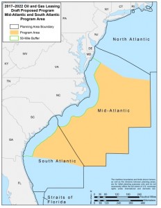
Offshore Drilling Puts Fragile Virginia Coast at Risk
CAPE CHARLES WAVE
February 2, 2015
The Obama administration has announced plans to allow oil wells to be drilled off the coast of Virginia and several other southeastern states, with Virginia’s coastline placed at particular risk. Virginia Eastern Shorekeeper Jay Ford expressed “extreme disappointment” with the decision — “Potential spills would have devastating consequences for one of the most unique habitats on our planet. Our aquaculture industry, fisheries, tourism, and culture would all be put at risk,” he said.
 Veteran journalist Peter Galuszka, writing in Bacon’s Rebellion, provides the following commentary:
Almost five years after the infamous Deepwater Horizon disaster in the Gulf of Mexico, President Barack Obama has again proposed opening tracts offshore of Virginia and the southeastern U.S. coast to oil and natural gas drilling.
The plan poses big risks for what may be little gain. Federal surveys show there could be 3.3 billion barrels of crude oil and 31.3 trillion cubic feet of natural gas in the potential lease area stretching from Virginia to Georgia.
Energy industry officials praised the plan while complaining it doesn’t go far enough. Environmental groups including the Sierra Club and the Chesapeake Bay Foundation condemned it. Besides the ecological risk, the move is a step away from refocusing energy on renewables that do not lead to more carbon emissions and climate change. [Read more…]
County-Wide Rezoning Could Be Adopted in August
January 26, 2015
STATEMENT FROM CITIZENS FOR A BETTER EASTERN SHORE (CBES)
Due to the public outcry over the Northampton County Proposed County-wide Rezoning, and the potential impacts of such zoning on the quality of life of all our citizens, CBES pledges to help keep you informed. CBES has examined the Board of Supervisors’ Packet released last Friday, and is circulating the draft of the zoning timetable below.
CALENDAR FOR ZONING ORDINANCE ADOPTION
- Jan. 26: “…review the revised draft documents and map to be sent to joint public hearing (only those items which have changed since the original March 2014 joint public hearing)
-
Jan. 29: Revised draft document is available for the public’s inspection on the County website.
- Feb. 19 and Feb. 24: Conduct two (2) public information meetings about the revised document and map. To be held at Kiptopeke Elementary School and Occohannock Elementary School.
- March 4: Board of Supervisors Recessed Meeting to review comments …”and decide if those comments need to be included in the revised documents.” (A decision must be made that night in order for the remaining calendar to hold true.)
- Apr. 22: Joint Public Hearing between the Board of Supervisors & the Planning Commission on the Zoning Ordinances & Map.
- July 31: end of review time by the Planning Commission.
- Aug. 11: “Next available Board of Supervisors Meeting where action can occur.”
Be-Lo Building Brought Low
 January 19, 2015
Mason Avenue’s biggest eyesore is no more. The old Be-Lo grocery store, run out of business when Food Lion opened on the highway, got a mercy killing this past week as developer Patrick Hand cleared the area for a mixed-use building with commercial storefronts at ground level and condos upstairs. Also falling victim to Hand’s development are 160 public parking places surrounding the old building. The town plans to lease parking space on railroad property a bit further walk to shops compared to the old lot. (Photo: Irene Munz)